 A Twitter from Mark Evans , Director of Community at PlanetEye told me that the service has launched in Beta. I clicked over to register and try it out.
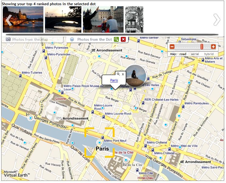
When you first arrive on the PlanetEye home page, a Search bar is front and centre on the page. I’m planning a trip to Paris, France, so, I typed in Paris and that took me to the Paris page.
I found that PlanetEye gives me three main ways to find and view information about Paris:
- a map as the central navigation feature with hotspots that can show photos, hotels, restaurants or attractions. Microsoft is an investor in PlanetEye and the site cleverly and effectively uses Microsoft Virtual Earth for its map-based features.
- a City Guide view that presents the same information in a text-based page organized under headers such as Top Hotels and Top Attractions .
- the Local Expert page which presents a blog by a PlanetEye rep featuring reviews of restaurants and tips about things to do when visiting the city. In the case of Paris, the Local Expert is a Canadian, Jolayne Attwood , who has been living in Paris for about a year. Her blog posts review the type of out of the way restaurant that you’d hope that a local resident would tell you about. She also offers pointers to seasonal festivals and exhibitions at galleries. All in all, I enjoyed reading her take on Paris and this feature alone will draw me back to PlanetEye as I plan my trip.
 Once I’ve found information, PlanetEye also offers a way that I can organize and save it for future use. Once I’ve registered on the site, I can create personalized pages which PlanetEye calls Travel Packs . I can save any type of information I find on the site in a Travel Pack – hotels, photos, reviews, etc. And I can make my Travel Pack private or public. By making it public, I can share my experience with other travellers, adding to the richness and usefulness of the site.
I also can upload my own content and geotag it. Geotagging is easy. PlanetEye lets you simply drag and drop photos you have uploaded onto the location on the map where you took them and then it assigns coordinates to them. You can see a photo that I uploaded and mapped to the location of Universal City Walk in Orlando, Florida. It took me less than three minutes to upload my first photo. Easy and quick.
I’ve created my first two Travel Packs for Paris and also for Orlando, where I’ll be going to attend BlogOrlando . The site helped me to find a hotel I wanted in the area I wanted to stay. When I decided it was time to book the hotel, the site took me to a Travelocity Partner booking page with its standard interface. I’ve begun bookmarking information on my Travel Packs and I’ll be watching to see if other travellers post content over time.
I’m going to add PlanetEye to the other travel sites I use regularly: Dopplr to share travel destinations with friends and to connect with them when I’m on the road and Travelocity (a longtime Thornley Fallis client) to book air, hotels and car reservations.
Now, with PlanetEye, I think I’ve found an easy to use way to pull together my videos, photos, favourite places and experiences for specific destinations, to share these with friends and family and to plan trips. Kind of like having flickr, youTube, a guidebook and a travel diary all in one place.
…
What other people are saying about PlanetEye:
ReadWriteWeb: PlanetEye: A One Stop Travel Destination
Mashable: PlanetEye, Blowing Other Travel Sites Out of the Water?
SensoryMetrics: PlanetEye Versus Travelpod
UberGizmo: PlanetEye: Plan Your Trip Using Virtual Exploration
